Mapping Threats from LNG Tankers in Southern British Columbia, Canada

Buildout of LNG export facilities and linked tanker traffic threatens people, ecosystems, and wildlife in the region.
LNG Buildout in Canada
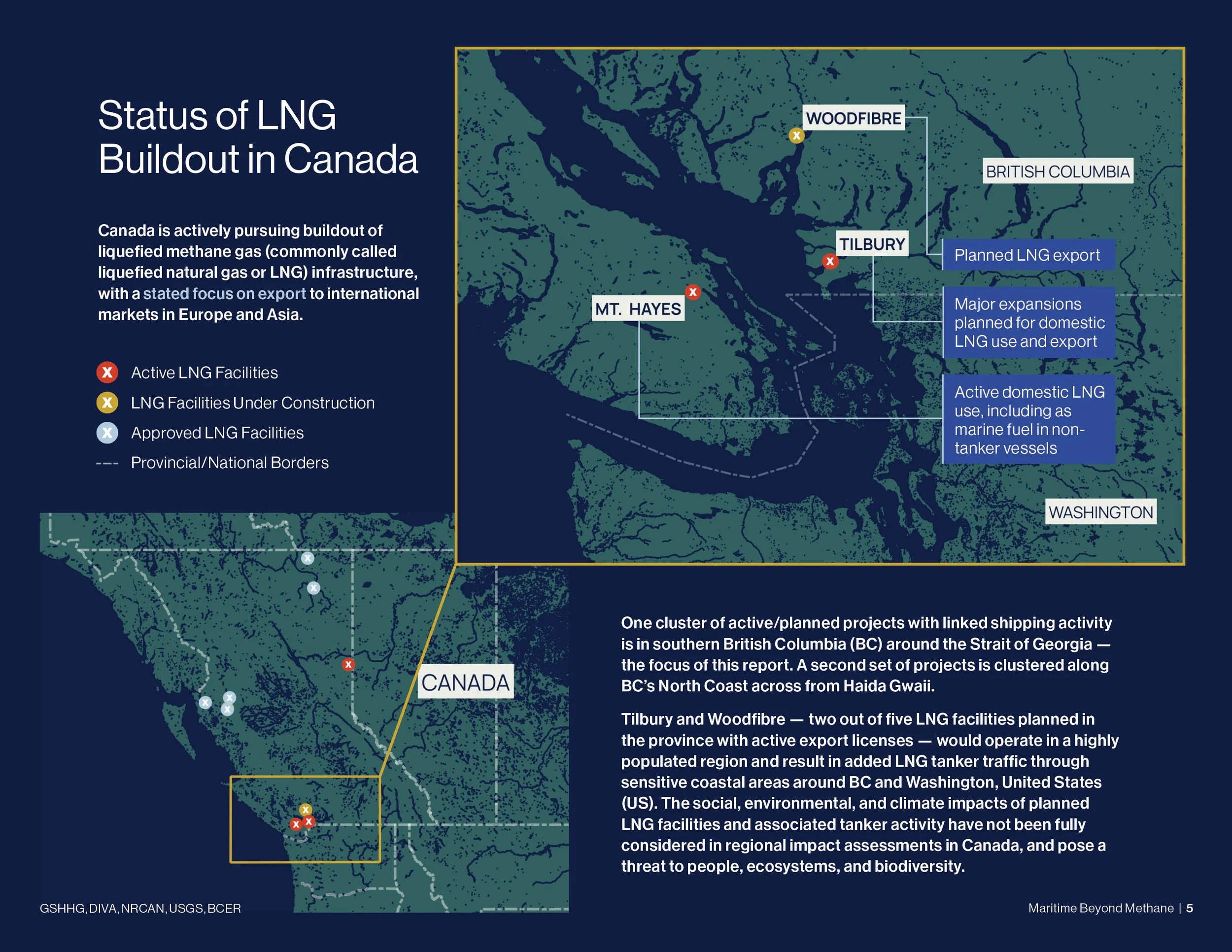
Canada is actively pursuing a buildout of liquefied methane gas (commonly called liquefied natural gas or LNG) infrastructure, with a stated focus on export to international markets in Europe and Asia. All currently active and planned LNG export projects are located near the western coast of British Columbia (BC), with one group of export projects clustered in southern BC around the Strait of Georgia (Woodfibre LNG and Tilbury LNG), and a second group of export projects clustered along BC’s North Coast across from Haida Gwaii (Ksi Lisims LNG, Cedar LNG, and LNG Canada).
Canada’s major LNG export projects are at various stages of approval and assessment, with one project active as of July 2025. Though these projects are subject to environmental assessment in Canada, there appear to be significant gaps in the assessment of impacts from LNG tanker traffic along Canada’s coast. Proponents of LNG export projects have claimed, in some instances, that aspects of marine shipping impacts fall outside of the scope of environmental assessments. In many cases, key information on LNG shipping impacts has been left out with a failure to consider the proximity of tanker traffic to sensitive marine and coastal areas (e.g., 4). Given that LNG tankers are an essential component of export operations, excluding their impacts represents a considerable oversight.
This report provides a high-level overview of the social, environmental, and climate impacts of LNG infrastructure in southern BC, with a focus on Woodfibre LNG and Tilbury LNG export facilities and their associated LNG tanker traffic (Figure 1). Additional LNG facilities in the region, including Mt. Hayes LNG, are considered in analyses due to their implications for bunkering LNG as a marine fuel for domestic use. The purpose of the report is to demonstrate the planned increase in LNG tanker activity on BC’s coast, what it could mean for people and wildlife in the region, and why it is critical to ensure impacts of LNG export are properly assessed in Canada and globally. The full report can be found here.
Key Findings
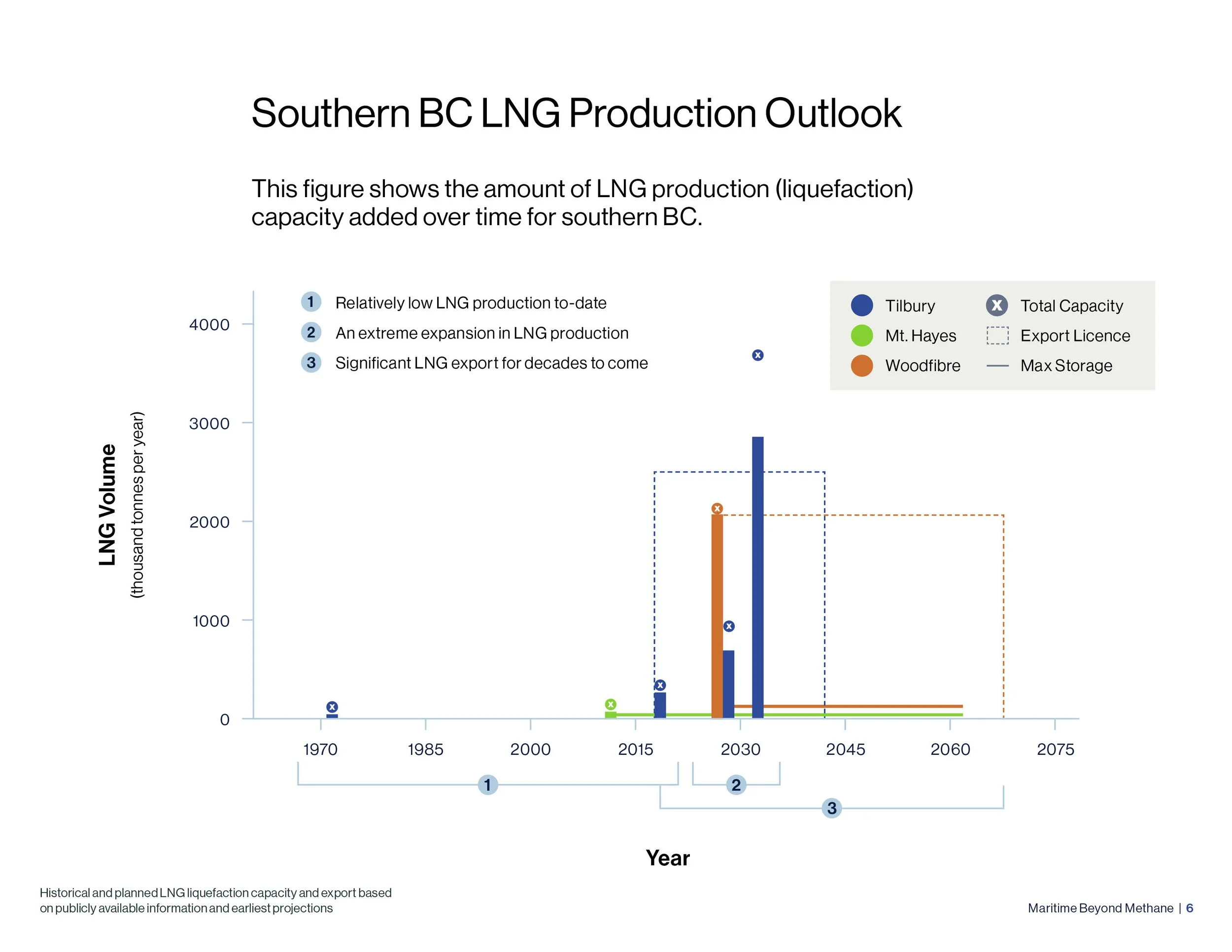
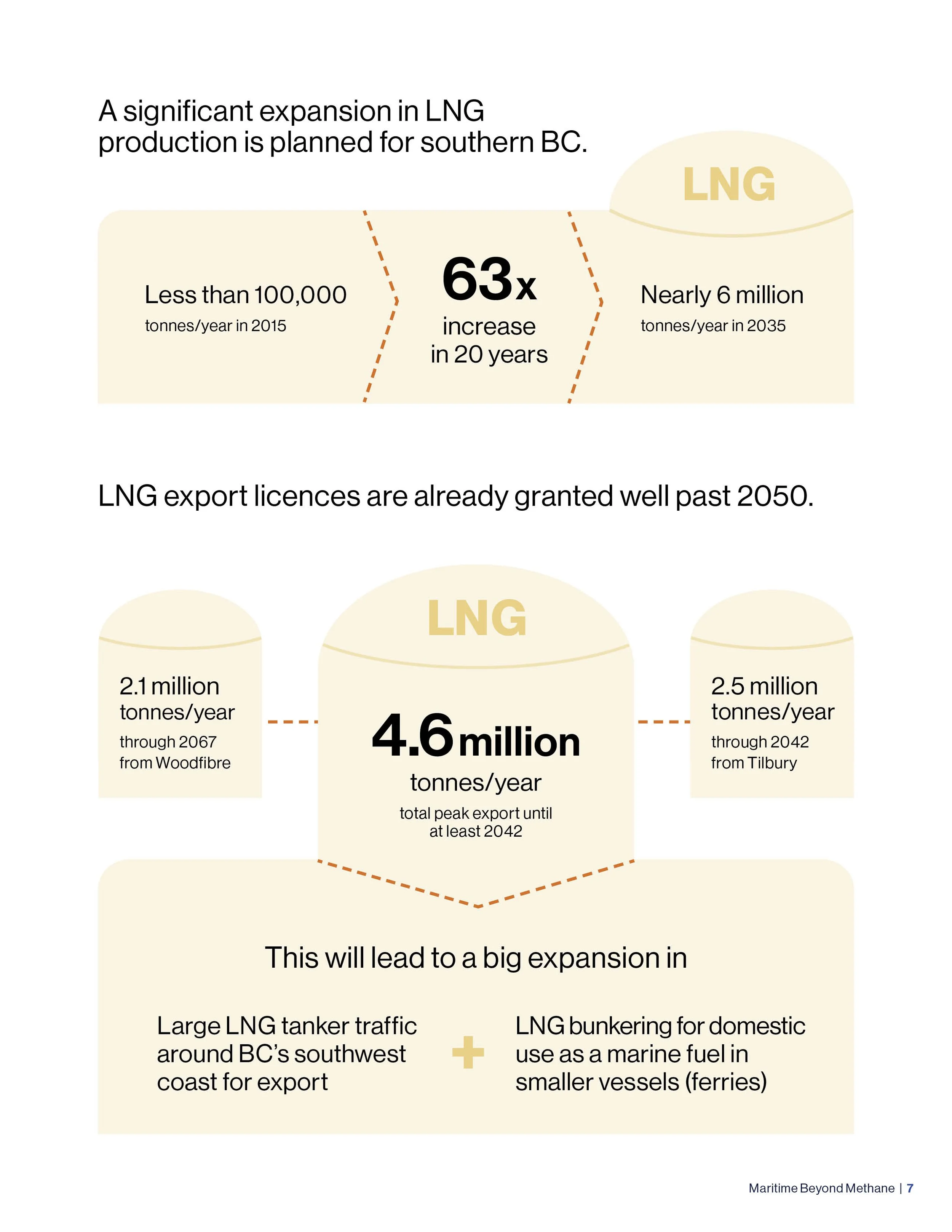
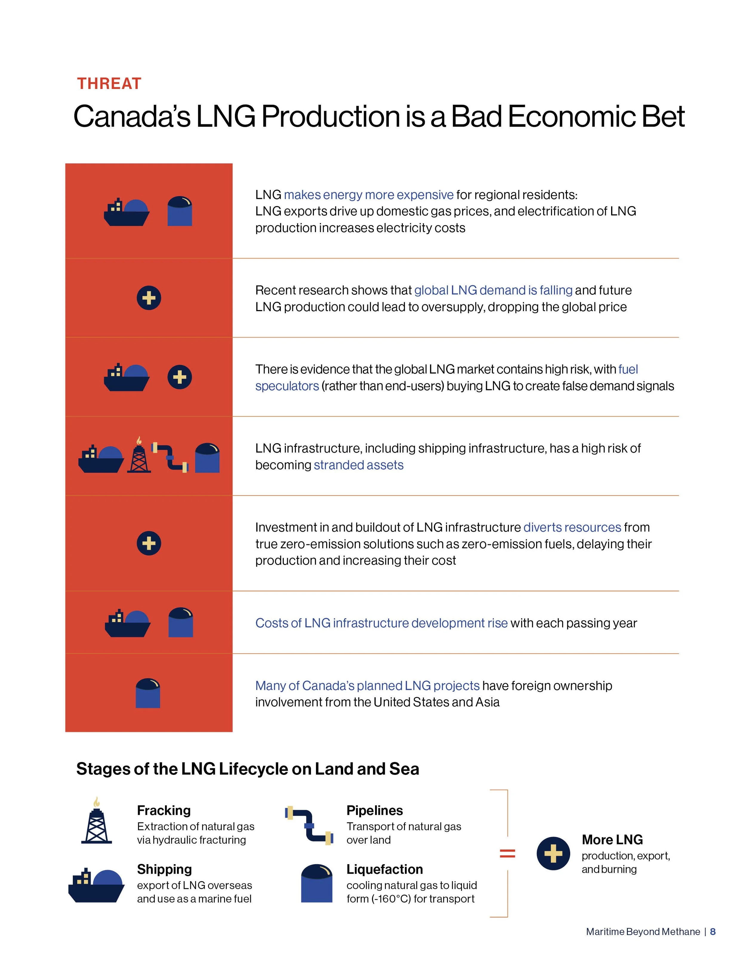
A significant expansion in LNG liquefaction for export is planned for southern BC over the next 10 years, at a time when global LNG demand is declining and a speculative market means risky economic conditions and the potential for costly stranded assets.
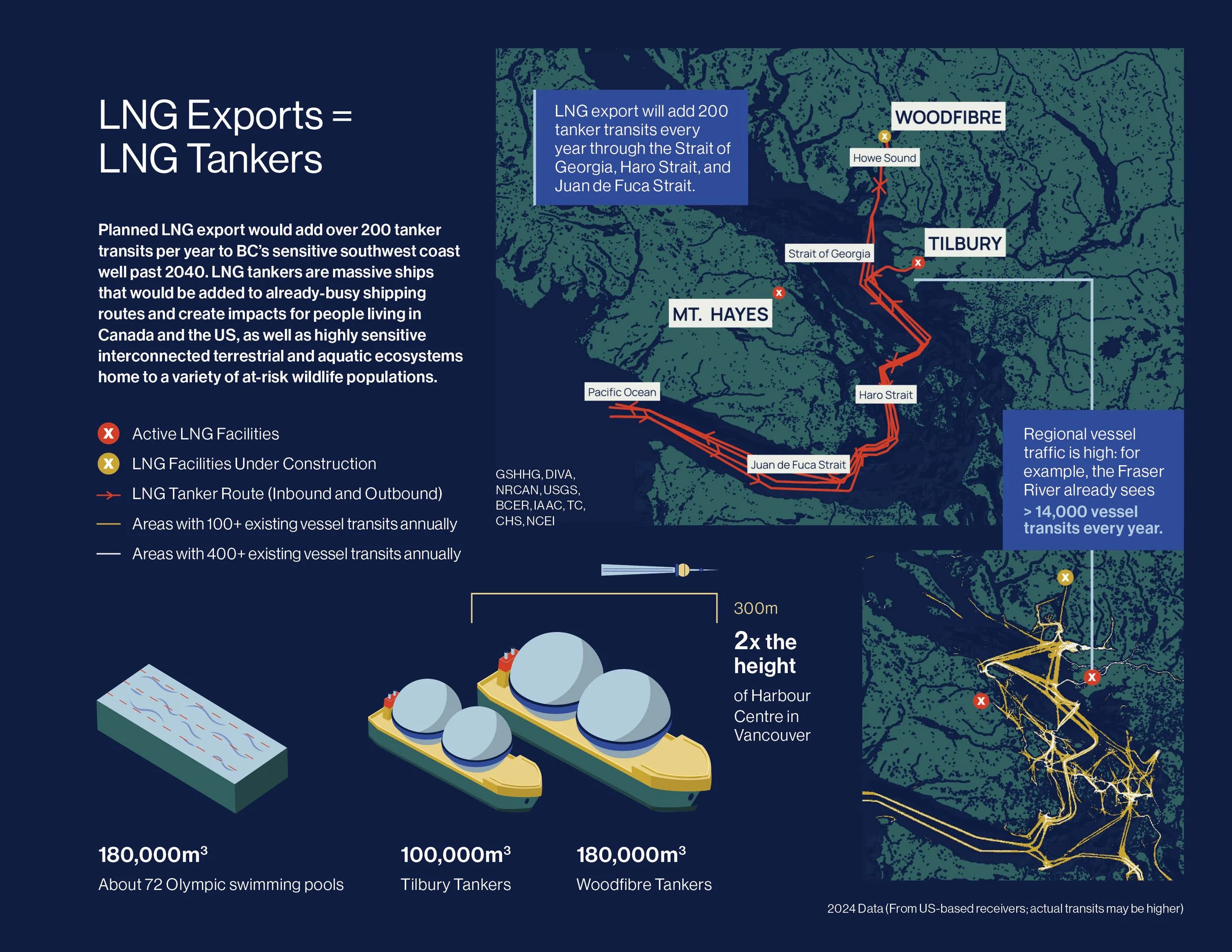
Planned southern BC LNG export equates to over 200 LNG tanker transits per year along BC’s sensitive southwest coast well past 2040, and an expansion in domestic use of LNG as a marine fuel indefinitely. All LNG vessel activity puts provincial and federal climate targets at risk and creates legal liabilities.
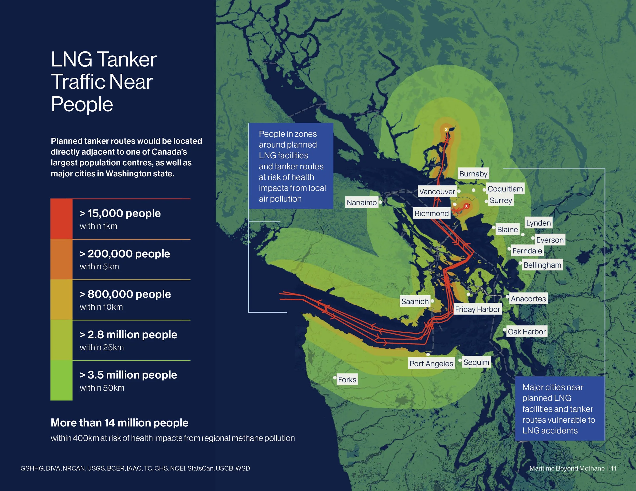
Planned export facilities and tanker routes for southern BC LNG projects put millions of people in Canada and the US at risk of health impacts from air pollution, with over 200,000 people exposed to localized impacts within 5km of planned routes/facilities, and over 14 million people exposed to regional impacts within 400km of planned routes/facilities.
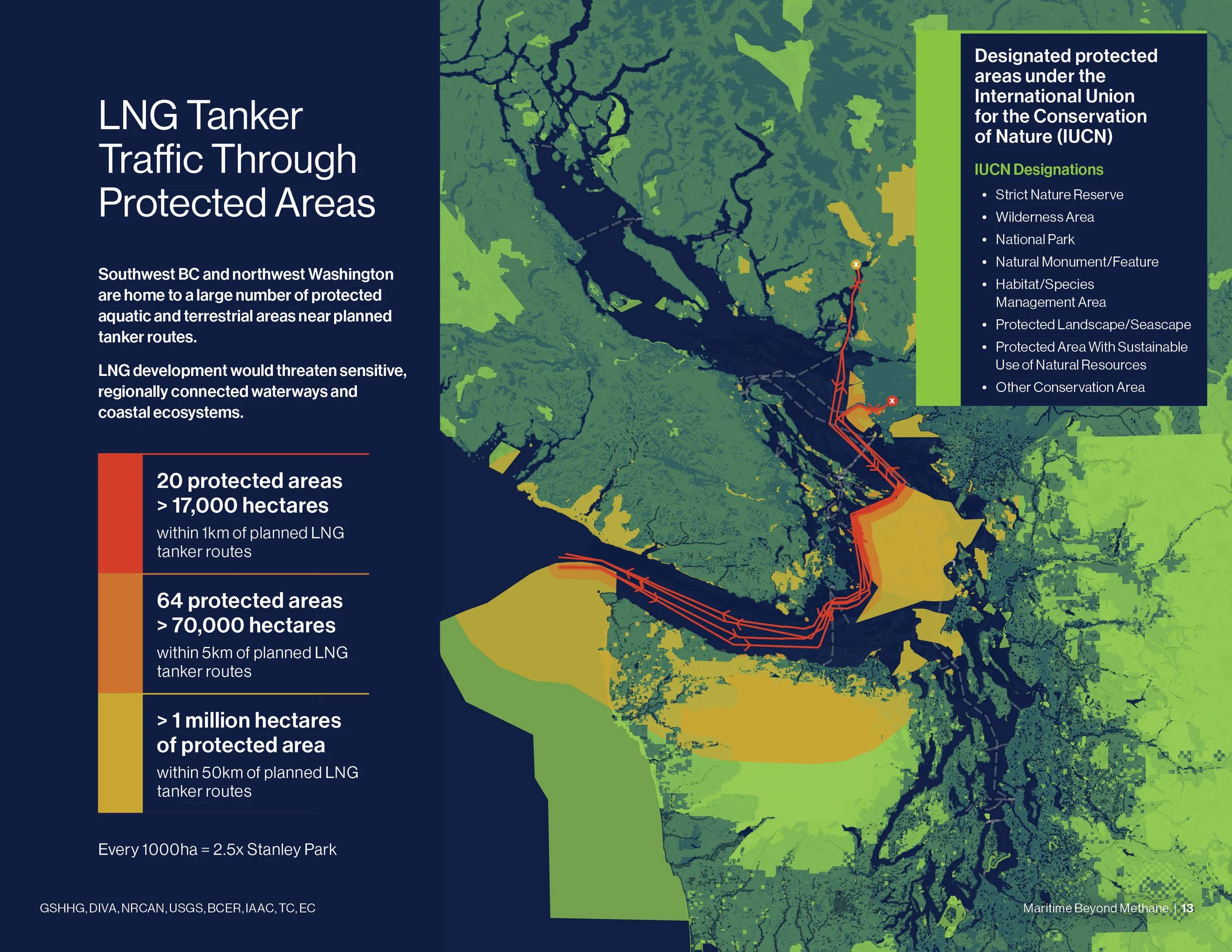
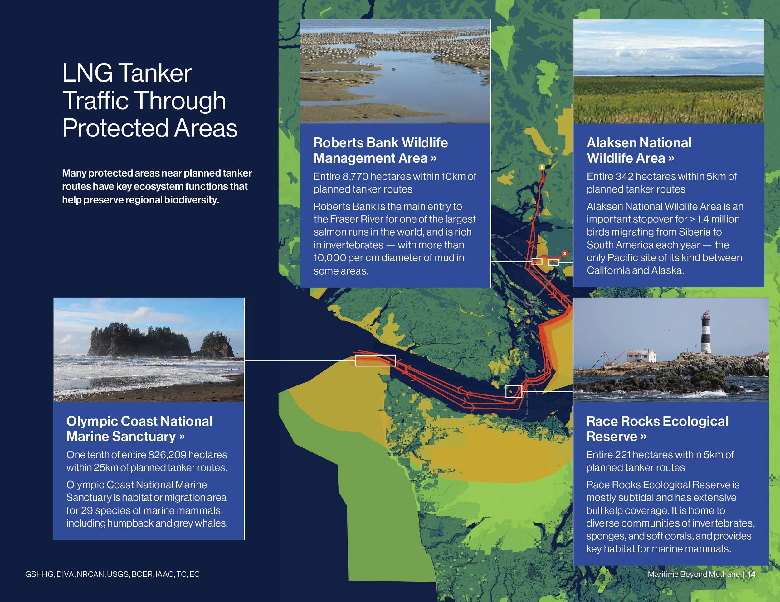
Planned export facilities and tanker routes are adjacent to over 1 million hectares of regional protected areas in Canada and the US, many of which have key ecosystem functions for sensitive species in the region that would be impacted by water/air pollution from tanker traffic.
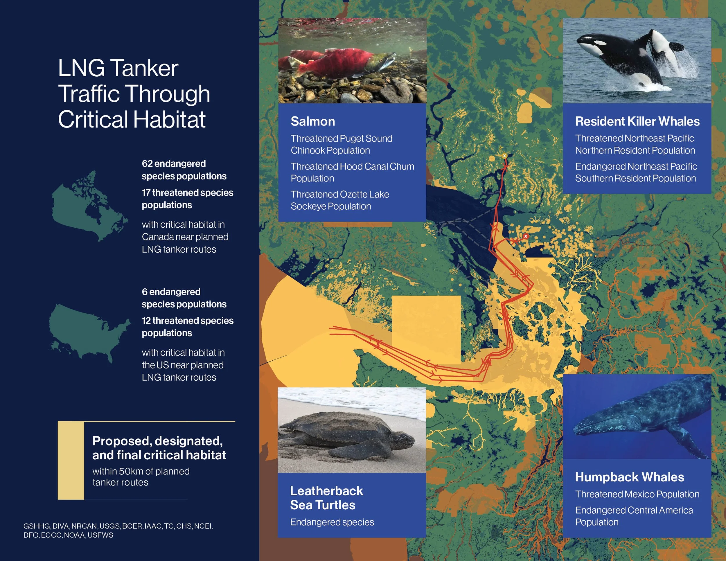
The majority of planned tanker routes — roughly 85% or 1,000km — pass through critical habitat in Canada and the US, and would hamper the recovery of threatened and endangered marine and terrestrial wildlife populations — including whales, salmon, and sea turtles — negatively impacting regional biodiversity.
-
Current export licences allow for LNG tanker traffic to reach over 200 transits per year along BC’s southern coast. This activity is projected to be continuing well past 2050. LNG tankers for both the Tilbury and Woodfibre export projects would pass through the Juan de Fuca Strait, Haro Strait, and Strait of Georgia.
-
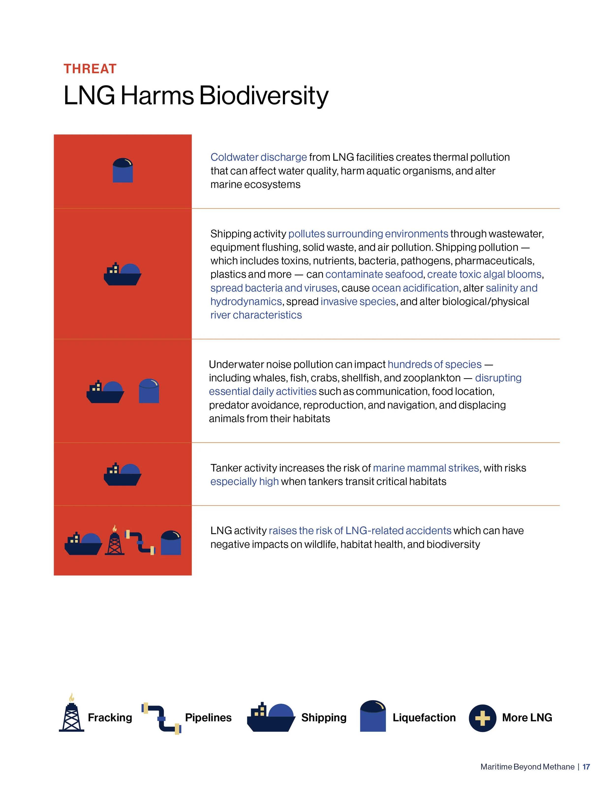
LNG tanker traffic contributes underwater noise pollution, which can impact hundreds of species, including whales, fish, crabs, shellfish, and zooplankton. Vessel noise can disrupt essential daily activities that many marine species require sound for, including communication, food location, predator avoidance, reproduction, and navigation. Additionally, LNG tankers raise the risk of mammal ship strikes, which are one of the leading causes of deaths for whales globally. Approximately 85% of the planned tanker routes is within proposed, designated, and final critical habitat for aquatic and terrestrial species at risk in Canada and the US.
-
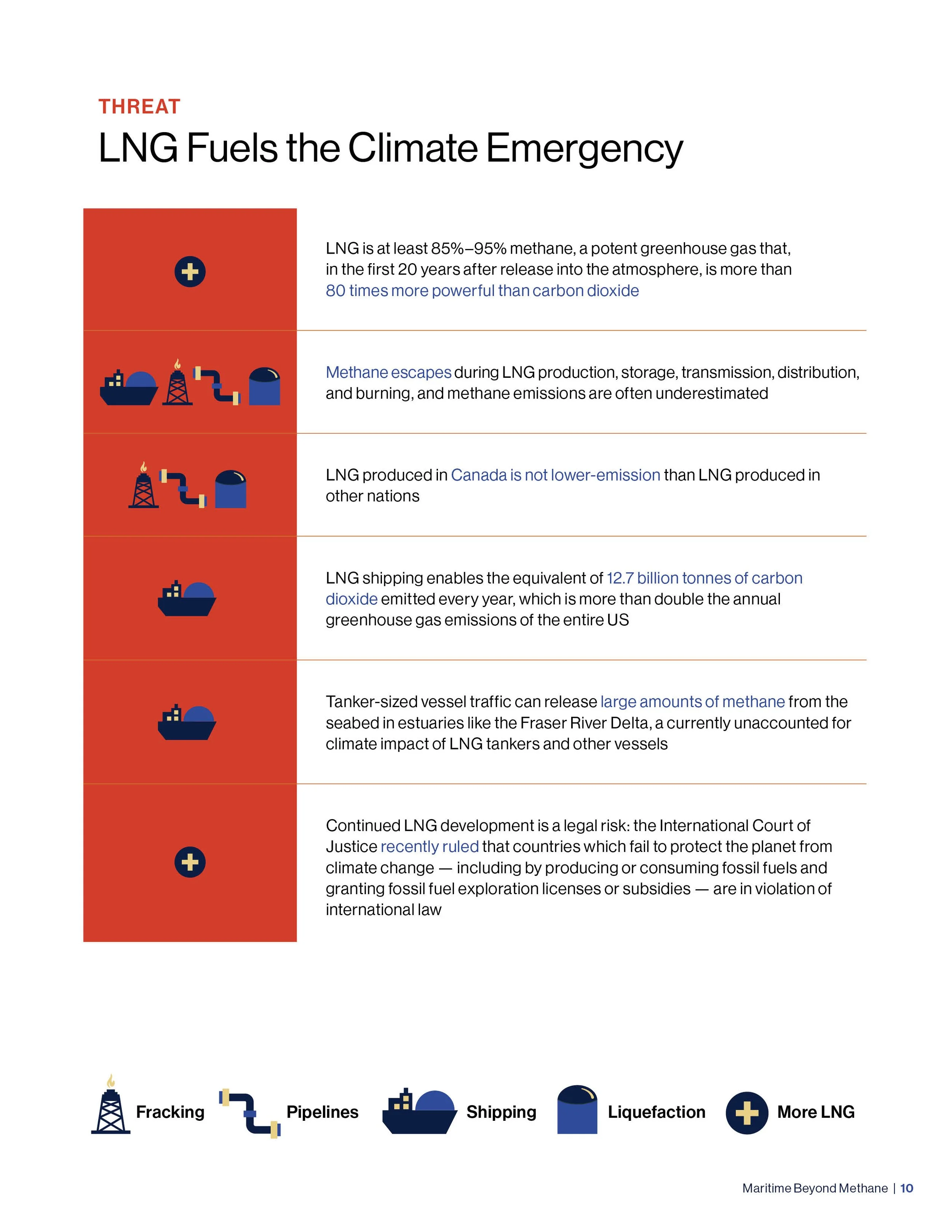
LNG is at least 85% - 95% methane. Methane is a potent greenhouse gas (GHG) that, in the first 20 years after release into the atmosphere, is more than 80 times more powerful than carbon dioxide (CO2) at trapping heat. A specific concern is unburned methane escapes from marine engines during transport (i.e., methane slip), which can have potentially damaging atmospheric impacts. The report concludes that LNG buildout is inconsistent with numerous climate initiatives in BC and Canada.
-
Ensure environmental assessment processes for LNG projects capture all relevant impacts of LNG development through proper scoping, including: a. impacts to all social, environmental, and climate component categories, b. life-cycle impacts of LNG linked to new LNG project infrastructure, such as its transport via tankers through regional waters and use as a marine fuel domestically, c. cumulative impacts of all planned LNG infrastructure provincially, nationally, and regionally
Adopt an intersectional and precautionary approach to impact assessment for LNG infrastructure and shipping, including implementation of solutions with co-benefits that address stakeholder concerns, such as limiting tanker traffic in areas which will adversely impact people and wildlife
Evaluate whether LNG infrastructure buildout and shipping traffic aligns with municipal, provincial, and federal management priorities to meet health, economic, environmental, and climate goals.
Consider restrictions on LNG tankers similar to the BC Oil Tanker Moratorium Act or the proposed 10 year LNG tanker moratorium in the Gulf of California, to avoid tanker impacts to human health, ecosystems, biodiversity, and the climate crisis